


ArcGIS Explorer
Description of ArcGIS Explorer
ArcGIS Explorer is a mobile application developed by Esri that provides users with access to maps and geographic information. Designed for both casual users and professionals, this app allows individuals to explore a variety of geographic data on their mobile devices, making it an essential tool for those interested in mapping and spatial analysis. ArcGIS Explorer is available for the Android platform, and users can easily download the app to begin utilizing its features.
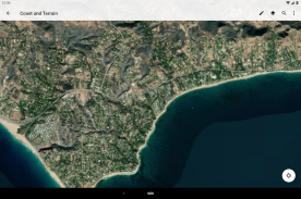
The application offers a range of functionalities that enhance the user experience when interacting with maps. Users can access their maps anytime, whether they are online or offline, which is particularly useful for those who may find themselves in areas with limited internet connectivity. This capability ensures that essential mapping information is always at hand, no matter the user's location.
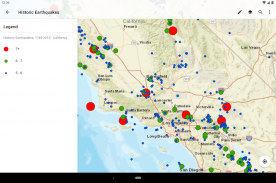
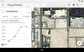
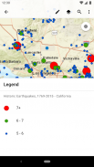
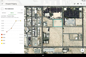
Searching for places and features is straightforward within ArcGIS Explorer. Users can input queries to locate specific landmarks, assets, or areas of interest within their maps. This search functionality makes it easy to navigate and find relevant geographic data quickly. Additionally, the app allows users to view detailed information about their assets, providing context and insights that may be necessary for decision-making or analysis.
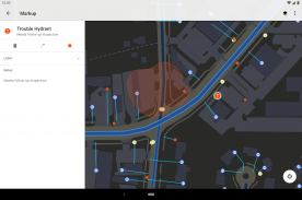
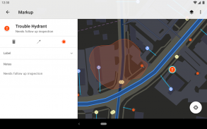
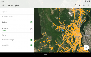
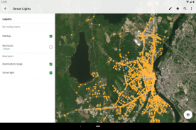
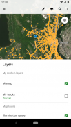
Marking up maps is another practical feature offered by ArcGIS Explorer. Users can annotate maps for personal use or share them with others. This capability is beneficial for collaboration, enabling teams to communicate effectively about specific locations or assets. Whether it’s highlighting a point of interest or drawing attention to specific regions, the markup tools facilitate a clearer exchange of information.
A compass feature is integrated into the app to assist users in locating hard-to-see assets. This tool aids navigation, especially in unfamiliar settings. By providing directional guidance, users can more easily orient themselves and ensure they are moving toward their desired locations. The compass can enhance the overall mapping experience, particularly in outdoor environments or complex urban areas.
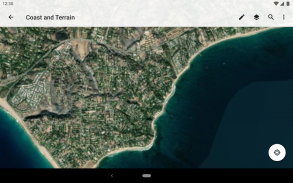
The app's interface is designed to be user-friendly, allowing individuals to interact with maps intuitively. Users can zoom in and out to examine details or get a broader view of the area. This flexibility in viewing options supports a variety of use cases, from detailed analysis to general exploration.
In terms of data management, ArcGIS Explorer supports the integration of various data sources. Users can import their data into the app, enabling a more personalized mapping experience. This feature is particularly advantageous for professionals who may need to analyze specific datasets related to their work. By incorporating their data, users can create more tailored maps that reflect their particular interests or requirements.
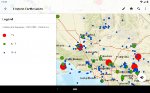
Another noteworthy aspect of the app is its capability to work with multiple types of geographic data. Users can visualize different datasets simultaneously, allowing for a comprehensive analysis of the spatial relationships between various elements. This feature is essential for those involved in urban planning, environmental studies, or resource management, as it provides a deeper understanding of the geographic context.
The app also supports sharing capabilities. Users can easily share their maps and findings with others, enhancing collaboration across teams or communities. This function allows for the dissemination of important geographic information, making it accessible to a wider audience. By promoting collaboration, ArcGIS Explorer fosters a sense of community among users who are engaging with geographic data.
For those who require real-time data updates, ArcGIS Explorer facilitates access to current information. Users can refresh their maps to ensure they are viewing the most up-to-date data available. This feature is particularly useful in dynamic environments where geographic information may change frequently.
The app’s ability to operate offline extends its usability in remote areas where internet access may be limited. Users can download their maps in advance, ensuring they have access to the necessary information even without a data connection. This offline capability is a significant advantage for fieldwork or exploration in less accessible regions.
Accessibility is another important consideration with ArcGIS Explorer. The app is designed to accommodate a wide range of users, from those with limited experience in geographic information systems to seasoned professionals. The combination of functionality and user support makes it a versatile tool in various contexts.
By integrating these features, ArcGIS Explorer emerges as a valuable resource for anyone interested in exploring geographic data. Its capabilities in map access, search functionality, data integration, and sharing create a comprehensive tool for navigating and analyzing spatial information. Whether for personal exploration or professional use, ArcGIS Explorer provides a robust platform that enhances the mapping experience across diverse applications.
ArcGIS Explorer - Version 20.2.2
(06-10-2020)ArcGIS Explorer - APK Information
APK Version: 20.2.2Package: com.esri.explorerLatest Version of ArcGIS Explorer
Other versions


 4.34
4.34


 4.63
4.63
Apps in the same category


